Mastering the Florida Keys Fishing Forecast
Planning a successful trip to the “Sportfishing Capital of the World” requires more than just a rod and reel; it requires real-time data and local intelligence. I’ve spent enough time staring at blank fish finders to know that “luck” is usually just another word for “preparedness.”
Quick Navigation
Florida Keys Fishing Hotspots Guide
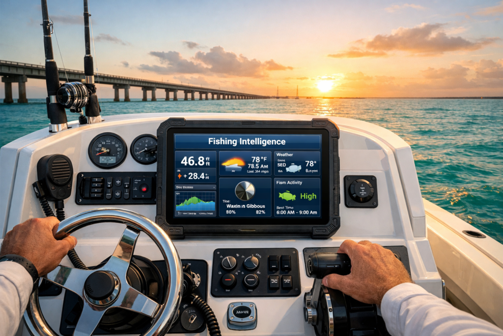
KEYS FISHING INTELLIGENCE
Syncing…Connecting to sensors…
Pro-Staff Hotspot Directory
Our Florida Keys Fishing Hotspots tool is designed to provide you with a professional-grade dashboard that rivals those expensive subscription apps. Whether you are hunting for Silver Kings under the 7-Mile Bridge or chasing Tuna at the Islamorada Humps, this guide explains how to use our live sensors to maximize your time on the water and minimize your time spent staring at empty blue waves.
Why a Florida Keys Fishing Hotspots Guide is Your Secret Weapon
In the Keys, the environment is your best friend or your worst enemy. I’ve seen guys head out to the reef in a 10-knot wind only to find themselves in 4-foot rollers because they didn’t account for the current direction. This tool aggregates everything—wind, tide, and barometric pressure—into one “Bite Index.”
If the index is below 50, that’s usually my cue to stay at the dock and work on my tan (or my boat’s wiring). If it’s above 80? I’m dropping everything and heading for the ramp. We provide this data so you aren’t just guessing based on a generic weather app that thinks “The Keys” is one single climate zone.
Real-Time Marine Weather and Radar Integration
The first step in any Keys fishing adventure is safety. Our live RainViewer Radar is centered specifically on the Middle Keys, allowing you to track those fast-moving tropical squalls that seem to pop up out of nowhere just when you’ve found the fish.
- The 10-Minute Rule: In the Florida Keys, weather can change faster than a tourist’s mind at a bait shop. By using the “Play” feature on our radar, you can visualize the direction of storm cells.
- Safety First: If you see a cell heading toward Vaca Cut or Sombrero Key, it’s time to pull the lines. We strictly follow ABYC safety standards for our electrical advice, but when it comes to lightning, our standard is “get to the dock.”
Understanding the Tide Trend and Bite Index
In the shallow waters of the Florida Keys, the tide is everything. If the water isn’t moving, the fish aren’t eating. It’s a simple rule of thumb that has saved me countless hours of wasted chum. Our tool doesn’t just show you the water level; it calculates the Tide Trend.
Experienced captains know that a “Rising” or “Falling” tide is often more important than the actual depth. A rising tide at Bahia Honda often triggers a massive Tarpon bite as they move in from the Gulf, while a falling tide at the 7-Mile Bridge is prime for Snapper waiting for a free meal to be swept out of the mangroves. To ensure our data is pinpoint accurate, we pull our primary water level metrics from the NOAA Tides and Currents stations located throughout the archipelago.
Solunar Theory and Feeding Windows
To truly fish like a pro, you must understand the Solunar Theory. It sounds like science fiction, but it’s really just about the moon’s gravitational pull on everything that swims. Fish are most active during specific “Major” and “Minor” feeding windows.
I’ve found that the “Major” windows—which usually last about 2 hours—are when the real monsters come out to play. Our Florida Keys Fishing Hotspots tool automates this math for you. If you can time your arrival at a spot like Alligator Reef to hit right at the start of a Major window, your odds of a multi-species day go through the roof.
Pro-Staff Hotspot Directory: Where to Fish Now
The heart of this page is our curated directory. We didn’t just pick these spots off a map; these are the iconic locations that have defined Keys fishing for generations.
- 7-Mile Bridge: The “Tarpon Highway.” I recommend using live shrimp or crabs on the shadow lines during a tide change. Just watch out for the bridge pilings—they’ve claimed more than their fair share of expensive lures.
- Sombrero Key Light: This reef is a haven for Grouper and Mackerel. We suggest silver spoons or deep-diving plugs. If you aren’t getting hits, try moving just 50 yards further out into the deeper current.
- Islamorada Hump: This is the big leagues. Located offshore, this is the place for Blackfin Tuna and Mahi-Mahi. Always check our wind limits before making the long run out—there’s no shame in turning back if the “Wind display” is showing double digits.
Technical Safety and ABYC Compliance
As a site dedicated to Marine Electrical Tools, we emphasize that a successful fishing trip starts with a reliable vessel. Before heading to offshore spots like American Shoal, ensure your battery banks are healthy using our Marine Battery Bank Size Calculator. You may also want to consider our Voyage and Power Range Calculator tool.
A failed bilge pump or a dead starting battery 20 miles out is a nightmare. All our technical tools are designed to meet ABYC E-11 guidelines, ensuring your boat’s electrical system can handle the load of modern fish finders, livewell pumps, and trolling motors.
Why Use Our Local Fishing Forecast?
Most national weather sites are too broad for the specific needs of a Keys fisherman. By focusing on the Marathon, FL corridor and the surrounding reefs, we provide a localized “Micro-Forecast.” From the Alligator Reef lighthouse to the backcountry flats of Turtle Rocks, our tool aggregates data from NOAA Buoys and local sensors to give you the most accurate picture possible.
Don’t just guess—use the data. Bookmark this page as your “Pre-Departure Checklist.” Check the Captain’s Top Pick for the day, grab the recommended bait, and hit the water with confidence.